« Building Hype |
Main
| ATLANTIC YARDS RATNERVILLE CONSTRUCTION UPDATE »
June 2, 2008
Downtown Brooklyn? New aerial photos show the context of the AY footprint
Atlantic Yards Report
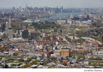 Norman Oder looks at recent aerial photos, project renderings and historical photos in analyzing the Atlantic Yards footprint and its relation to its surroundings.
New aerial photos of the Atlantic Yards footprint and environs, taken by photographer Jonathan Barkey as part of the sequence used for the Municipal Art Society's Atlantic Lots presentation, shed additional light on the context for the planned project.
...They show a much lower scale to the south in Prospect Heights and Park Slope. They show a good number of relatively smaller high-rise buildings in Clinton Hill and Fort Greene. (Here's an overall Brooklyn list of finished and proposed towers from Emporis.)
They confirm that towers completely or planned in and around the Brooklyn Academy of Music (BAM) Cultural District would form something of a connecting skein of high-rise buildings to the Williamsburgh Savings Bank tower. However, Atlantic Yards would still be a dogleg extension of Downtown Brooklyn and thus does not deserve that moniker, despite Forest City Ratner's rhetoric.
Posted by eric at June 2, 2008 8:42 AM